14-Sept-2013
295 mi. - 16,000' - 18:30 - 1st Place
I first found out about the Hoodoo 300 last October at the Solvang Autumn double century. I had known of the Hoodoo 500, a super challenging ultra cycling race starting and ending in St. George, Utah. But this would be the first year the promoter, Planet Ultra, offered the shorter 300 mile option. My interest was piqued right away. I immediately signed up in December. For nine months there was a big circle around 9/14 on my calendar.
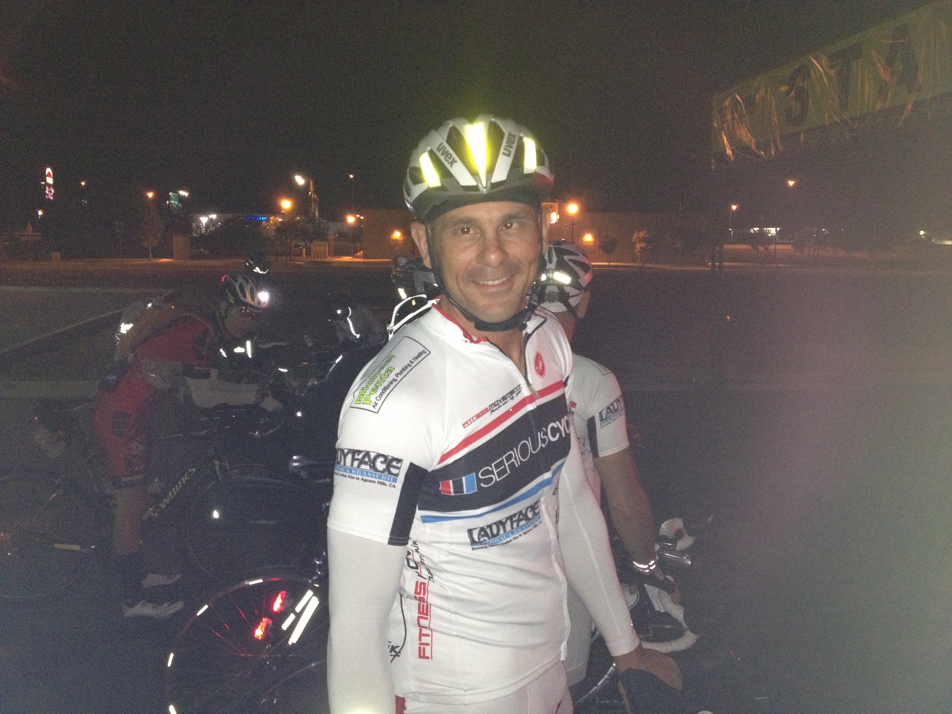
I had decided to enter the "Nomad" division, which meant I would be without a SAG vehicle and crew to hand me bottles and food, carry backup wheels, have extra clothing for every possible weather contingency, etc. Instead, I would only have three dropbags with food, one each at three time station checkpoints along the route. Otherwise I would have to be self-sufficient. Going Nomad also meant starting in the dark at 5 AM (and finishing after dark, too) so I had to have two independent sets of headlights and taillights, and have reflective tape on the frame, cranks, and helmet visible from all four sides. Lastly, I was required to carry a jacket and leg warmers. I don't have experience wearing backpacks or Camelbak while cycling, so I strapped everything possible to the bike, along with extra cages for two additional water bottles.
 "Bride of Frankenstein"
I was a little apprehensive about doing the race unsupported without being familiar with the route. Accordingly, I went to St. George with my sister Adrienne on the Labor Day holiday weekend and rode most of the course over three days. The recon trip provided me information that would prove to be invaluable during the race.
The 300 mile route starts in St. George, and travels through Hurricane, Colorado City, Kanab, Carmel Junction, Panguitch, Cedar City, and back to St. George. There are many considerable climbs on the route and even more smaller hills and rollers along the way. The highest point is the top of Cedar Breaks, 10,600', at mile 185. Other than the beginning and end of the loop, the middle 85% of the course is above 5,000' elevation.
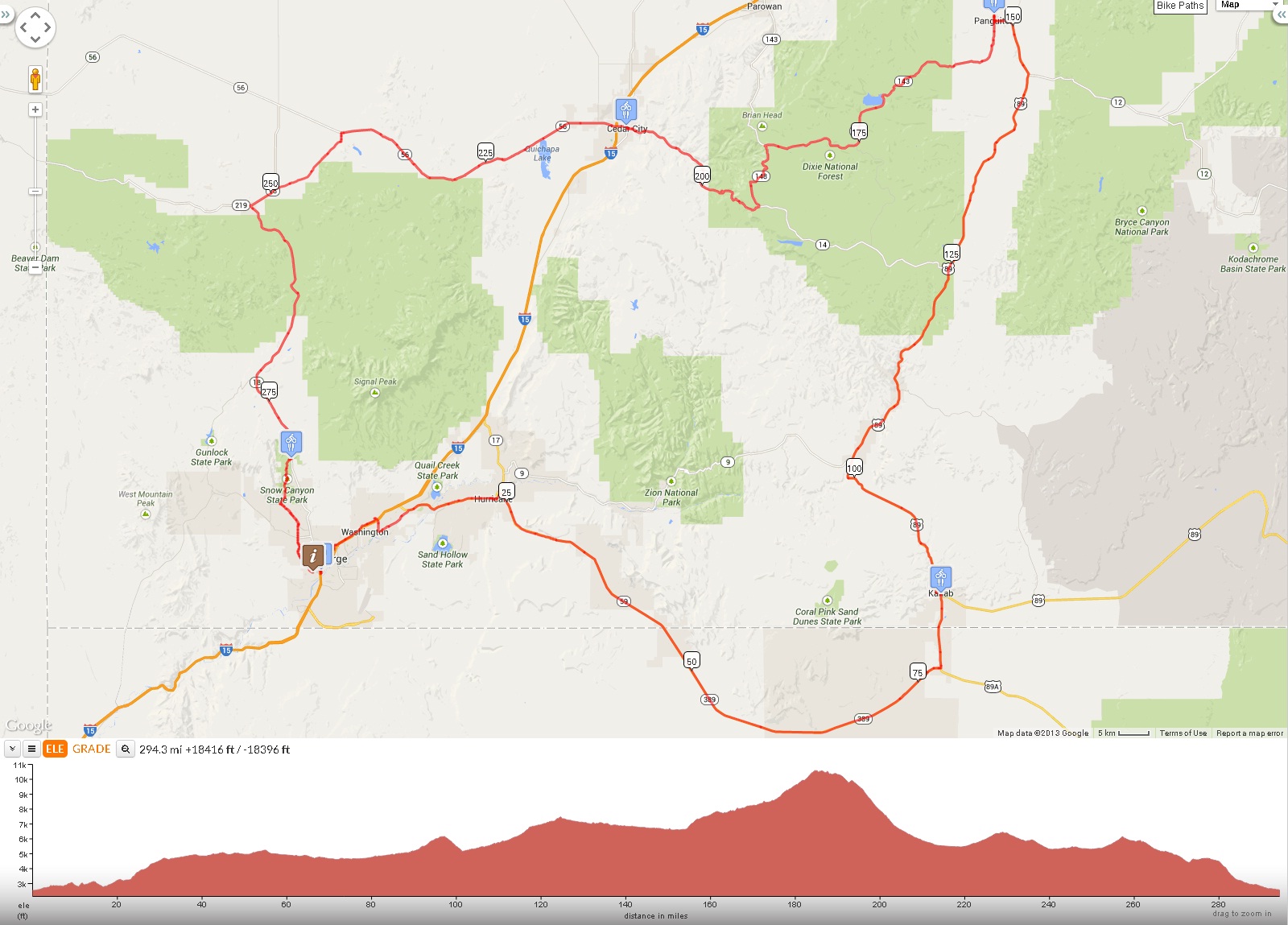 http://ridewithgps.com/routes/3289334
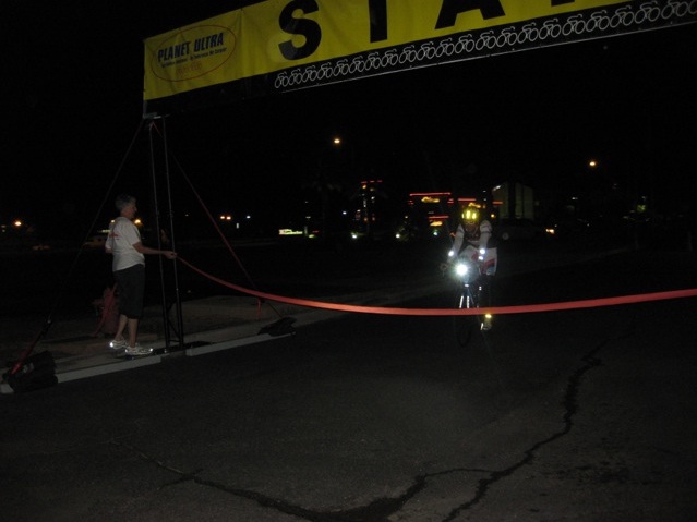
The race begins with an 11 mile neutral start, traveling through St. George and the suburb of Washington. During this neutral start we're allowed to ride in a group and draft each other. After that, the race is a time trial; drafting is prohibited and riders must maintain a 30' separation except when passing.
On Friday, September 13 my family packed into our minivan and we drove to St. George. We had booked a room at the host hotel, where the race would begin and end. All unsupported riders were required to have their bikes and helmets inspected for proper lighting and reflective materials. The supported riders had to have their SAG vehicles checked. Later I attended the prerace meeting where all the racers were introduced and we were given some information about the course, rules, etc. It's always nice to see everyone without helmets and spandex!
 registration "mugshot"
In between the registration and meeting I finished assembling my dropbags. Each contained a large bottle of high-protein Ensure, HEED (electrolyte powder) for two bottles, pills (salts, amino acids, joint health, lactic acid buffers, etc.) separated into small bags to be taken at specific points, chamois cream (in three separate small bags), and some portable foods I could eat while riding. The dropbag for the half way checkpoint also contained a vest and gel flask.
After the meeting my family and I walked to a restaurant across the street for a late dinner. Later back at the hotel I taped a cue sheet to my toptube listing the distance of each time station, significant summit, and locations where I'd planned to consume the bags of pills from my dropbags.
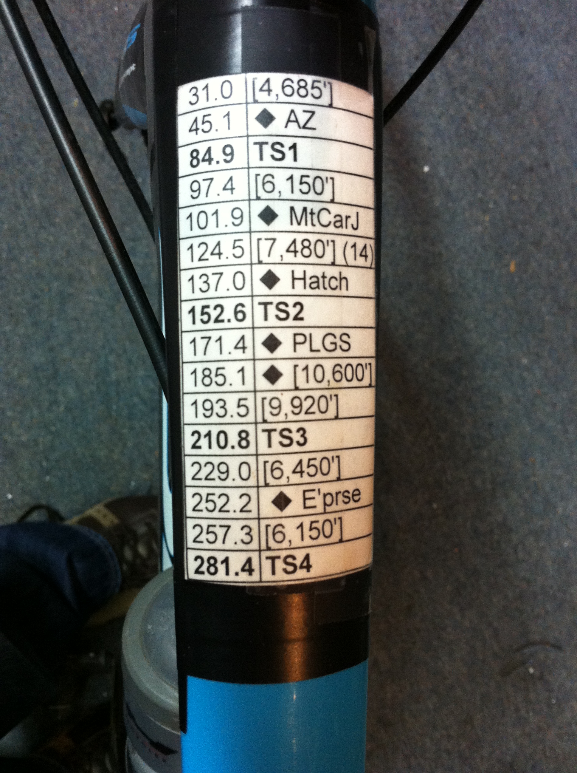 cuesheet
This would be the first time I had ridden over 200 miles. I knew I could ride the 300 mile distance, but I wanted to go fast and put in a respectable time.
My goal was to finish in 18 hours or less. The schedule was as follows:
To achieve this pace I would have to spend as little time as possible off the bike. I figured I spend about 15 minutes at each TS. Hopefully I could make it to each TS on four bottles and not have to stop and buy water.
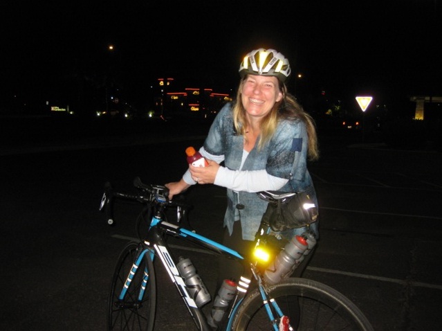
I woke up at 4:10, got down to the start/finish 10-15 minutes before the start time, and lined up along with all of the 300 and 500 mile distance riders competing in the unsupported category. Deb took pictures while we waited to start. The temperature was in the 60s; not too bad for 5 AM. I was wearing my white Serious Cycling race team kit and white arm sleeves.
 Not nervous at all...
During the neutral start, I chatted with some of the other riders and later stuck myself on the wheel of the fastest rider in the bunch, who turned out to be Hoodoo 500 veteran David Haase. After the neutral start ended, Dave rolled up the road and I followed at a legal separation. All the others were much further back, deciding to start off at an easier pace. Dave flatted before reaching Hurricane, so I had the pleasure of being "the leader" for a while.
It was still dark when I got into Hurricane [mile 23] and turned onto Hwy 59. There began the first real climb of the day. Over the first 2.5 miles there are two steepish 7% stretches, and then the gradient eases as it continues to the summit, 4,700' at mile 31. One mile or so from the top, Dave caught up to me and complimented me as he went by. The sun was just coming up.
I mostly stayed one or two tenths of a mile behind Dave as we rolled past fields with cows into Arizona [mile 45] and up towards Pipe Springs [mile 64]. This whole section is actually a very gradual climb and gradual descent towards Fredonia [mile 77]. Dave pulled further ahead of me, and I decided it best to ride my own pace. I was feeling fine and riding a little bit ahead of schedule.
Before Fredonia was a road construction zone where the highway was reduced to one lane. Temporary traffic lights were erected at each end to regulate traffic. Dave got stuck at the light and I rolled up to him just as it turned Green. Again, he pulled away from me, going just slightly faster than I was. In Fredonia we turn left, heading north on Hwy 89 towards the Utah border [mile 81].
Back into Utah the road climbs gradually. There was another road construction site here, and another one lane section. Once again, I caught up to Dave as he waited and we got the 'go' signal from the worker right as I pulled up. Again he pulled ahead of me going a bit faster up to the town of Kanab, 5,000' elevation, and our first Time Station [mile 85].
Officially, Mr. Haase arrived at TS1 at 9:36 AM and me at 9:38 AM. The Time Station was the parking lot of a closed down restaurant. Jennifer Klausner, Rick Jacobson's woman, was manning the checkpoint. Rick's van was filled with our dropbags and water. Dave was stuffing his goodies into his pocket and rolled away as I was reaching into the van for my bag. (That would be the last time I saw another racer.) I added HEED to two bottles and filled them all up, downed pills, guzzled the bottle of Ensure, stuffed items into my pockets, texted my family, rubbed Eucerin cream on my butt, and took a piss on Rick's left front tire! I was stopped there for about seven minutes.
Rolling through Kanab, I started my mp3 player and stuffed one earbud in my right ear. (First song: Simon and Garfunkel, Bridge Over Troubled Water.) The sky was clear and sunny. The temperature had warmed up to low 70s. After Kanab there's a good 1,200' of climbing up to 6,150', past mile 97. On the 5-6% sections I thought about my deceased brothers and my wife's cancer-sick friend (who unbeknownst to us had died the day before). The temperature went into the 80s on the climb. It felt great to reach the top and then hit the first real decent of the ride, back down to 5,200' and into Mt. Carmel Junction [mile 102].
Leaving Mt. Carmel Junction there's more gradual climbing again, a false summit, 6,800', around mile 118, followed by more climbing to the true summit at Hwy 14, 7,450', around mile 125. It was on this last part of the climb around mile 120 when the weather turned. The skies darkened and the rain began falling. At times the rain fell so hard it felt like hail, but I just kept rolling over the top and down the gradual descent towards Hatch. The rain stopped a mile or two past the summit, but the damage was done. I was completely wet all over, my shoes and socks soaked.
The road is mostly a flat-ish gradual descent from the summit at mile 125 to the next Time Station in Panguitch. The temperature was around 60 degrees and rising. I was able to dry off, but my shoes were still wet when I reached the Panguitch Time Station [mile 152].
TS2 was a room a the Color Country Motel. I arrived at 1:43. Inside I used the toilet and followed my same routine: HEED and water in the bottles, guzzle Ensure, apply more chamois cream, take pills, empty pockets of trash, fill pockets with more goodies and a new gel flask, wash face and hands, text family. I also stuffed the folded up vest from my dropbag under my jersey behind my neck. I was stopped for about 15 minutes.
Leaving TS2 I headed south through town and then began the big climb of the day, from Panguitch at 6'600' to the Cedar Breaks summit at 10'600'. Early on are some steep sections, but it's mostly easy climbing with some downhill sections for roughly 20 miles. The last 10 miles is the difficult part, where the climbing is mostly 5-7% for six or so miles, with some steeper sections along the way, before the climb eases to the top. Unfortunately, I felt awful on the Cedar Breaks climb. I tried my best and just kept plugging away, but I was pretty dead-legged. The skies got greyer the higher up I went. I kept thinking it was going to start raining, but it thankfully never did.
I was pleased to reach the 10,600' summit at mile 185, but I had lost 30-45 minutes along the way up and was now behind schedule. Past the summit is not a true descent, but about 8 miles of gradual downhill with rollers followed by a short climb to 9,900' [mile 192], and then the fun starts. It was on this section before the descent I was able to put on my vest and some latex gloves on my hands while cruising down the road. Although it was close to 60 degrees here, I was pretty chilly from being damp and having the cool air on my skin. I thought about trying to pull out my leg warmers from one of the bags under my seat, but decided against it.
The first part of the descent was a little twisty and fast. I was coooold. When I got to the turn to Hwy 14 [mile 198] I decided to stop and put on my leg warmers. Yes, you can put them on while riding -- it's easier to take them off than to put them on while riding -- but with cold hands I decided it was safer to pull over. Unfortunately they were a bit damp from the rain. (I should have put them in a plastic bag.) Still, though, it was better to wear them. Because of the odd arrangement of bags and bottles under my seat, it took longer than you'd expect to get them on and get back riding again. I was stopped there for five minutes.
The descent on Hwy 14 is fast with mostly long straight sections. Were I not so cold and tired I would have tried to go faster, but I alternated between a nice tuck position and standing up to stretch out my back. Towards the bottom where the gradient was leveling off, I realized I had a flat front tire. It was down to 40-50 psi. I pulled over and changed the tube, carefully inspecting the tire in the process. It looked fine, but I couldn't find what had caused the puncture. So that was another five minutes off the bike. Two miles later I was in Cedar City, elevation 5,750'.
TS3 in Cedar City [mile 211] was another motel room. I arrived at 6:25. Same drill as the other stops. I also switched the lenses on my glasses to the clear ones. My feet were mostly dry by now. By the time I got back onto the road, I was almost 45 minutes behind schedule. No worries. Just keep going.
Heading west on Hwy 56 it started getting dark. Then, it started raining again. I was cold even though I was still wearing the vest and leg warmers. I used my headband to cover my ears. This time the rain wasn't so heavy. My clothes were getting wet, but my feet and shoes weren't getting much worse than they already were. Hwy 56 has a twelve mile stair step climb that goes anywhere from flat to 5%. I didn't feel like I was flying up it, but I felt much better than I did back on Cedar Breaks. The summit, 6,450', at mile 229 came sooner than I expected. The rain stopped. I continued to the next turn at Newcastle [mile 241].
Leaving Newcastle I was "attacked" by the same yappy chihuahua I encountered two weeks earlier. By now it was full dark and was using both taillights and alternating between using just one or both headlights. From Newcastle to the next town, Enterprise, the road is slightly uphill for the first half and then slightly downhill for the second half with a handful of cattle guards along the way. Once again, I wasn't tearing up the road, but I was definitely moving along nicely and feeling pretty good, all things considered.
At Enterprise [mile 252] I was having difficulty getting a bag of pills from my pocket while moving and wearing the gloves. I stopped for a brief minute to get out the pills and swallow them. That would be my last unscheduled stop of the day. Leaving Enterprise on Hwy 18 I ascended the last "long" climb of the day. It was five miles long at 4-6% up to the 6,150' summit [mile 257]. I settled in and chugged up at reasonable pace. There was little traffic on the highway and everyone noticed me, lights and all, and moved over to pass safely.
The temperature now was around 60 degrees. Despite the dark, and all the hours of cycling, I was relatively comfortable on my way down into Veyo at mile 272. Leaving Veyo is the last climb of the ride. It's a nasty 7% grind for over half a mile followed by a short descent and then a few more miles of gradual 2-4% uphill. I briefly started worrying about missing the turn to Snow Canyon, but then my mind perked up and I recognized the right hand bend in the highway which leads to a nice fast descent to the Snow Canyon State Park turn off. I'm all smiles now.
"State Park Next Right" said the sign. I pull into the turn lane and into to parking lot at the top of Snow Canyon, TS4, mile 281. It's 10:50 PM. I down my final bag of pills and duck into a conveniently located portapotty to take a leak. I pull out my phone and call my wife. "Come down with the kids to finish in 30 minutes." Then I call Deb. "It's Brook Henderson, I'm about to descend Snow Canyon." Honestly, I don't know who was happier to get my call.
From here to the finish is a twisty four mile descent followed by nine miles of flat/downhill back to the host hotel. The Snow Canyon descent is tricky; better safe than sorry, I said. At the bottom I reached a traffic circle where I needed to make the equivalent of a left turn. However, on my right is a stream of traffic, folks exiting from a local live theatre show. I was waving my arms like mad just to make sure I was seen as I merged in and started down into town. "I'm smellin' the barn!"
I burned down Snow Canyon Parkway, dodged the wheel-eating manhole covers on Dixie Downs, got stuck at one red light, grind-grind-grind, and then I saw the "600 WEST" street sign. Last mile. From here I got on the sidewalk, rolled down onto the bike path, under I-15, and back onto the road. A quarter mile up the street I can see and hear my daughters at the finish in the Hilton parking lot.
 Almost there!
Done. 295 miles. 11:30 PM. Deb and Jann greeted me with much enthusiasm. Sharon and the girls echoed my smiles.
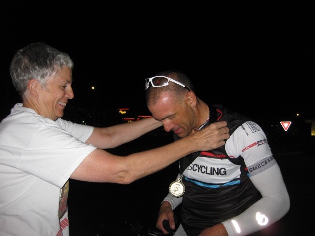 medal
medal
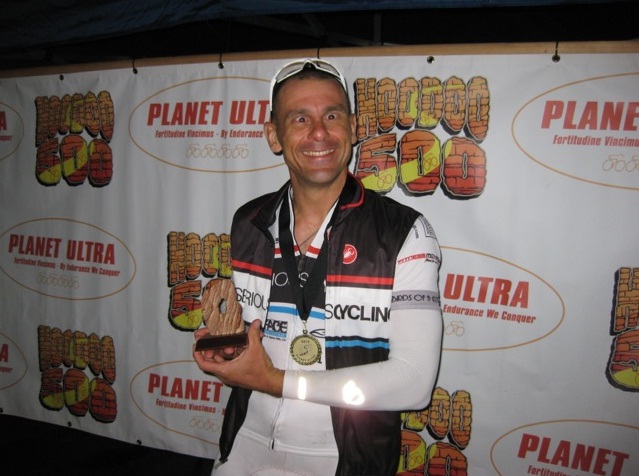 Tired and happy
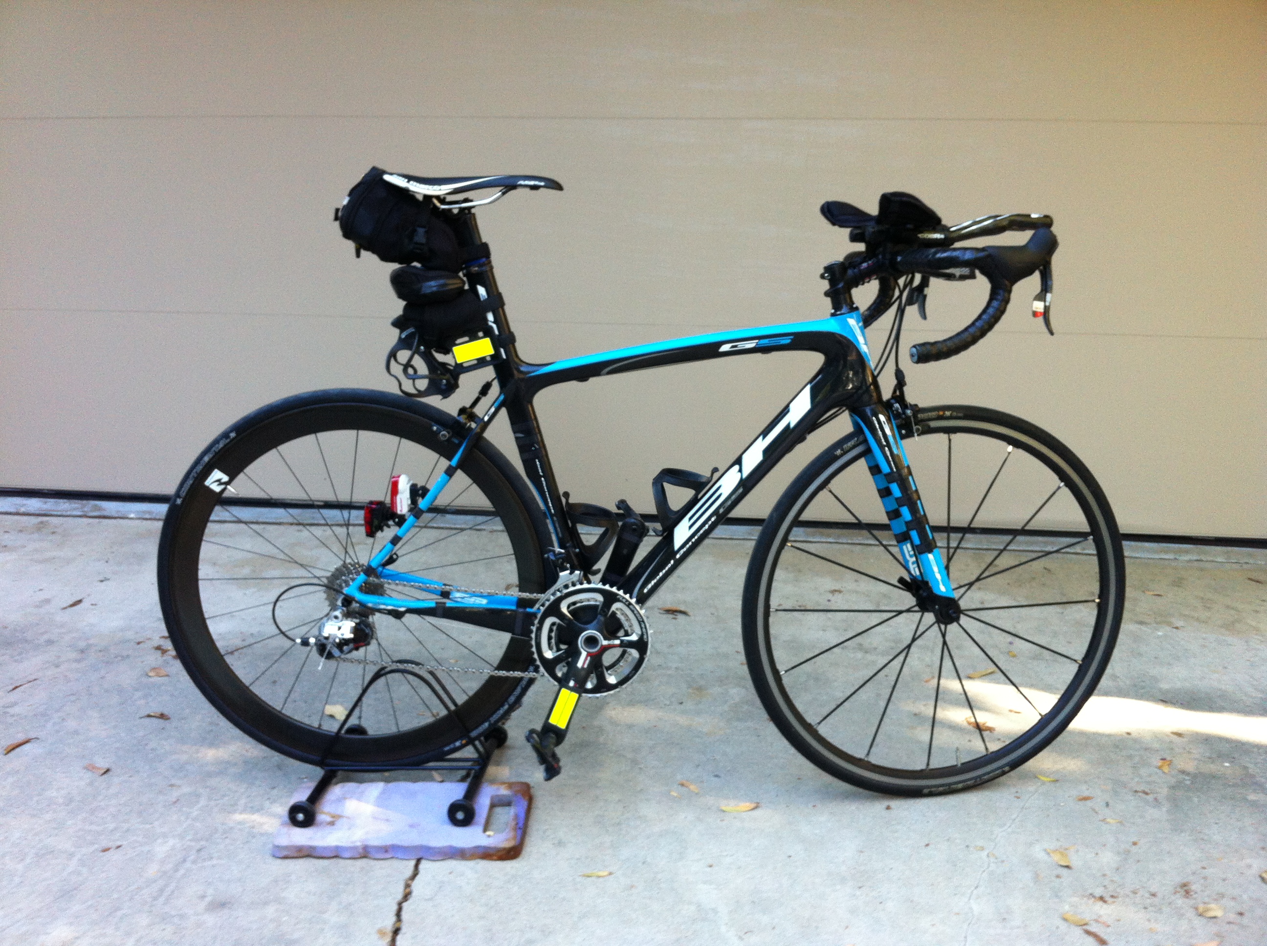
 Sharon acting as bike caddy. Note the reflective tape on the forks and stays.
An hour later everyone was asleep in the hotel room except me. After a well needed shower, I decided to drive over to Denny's. I ordered the fish and chips special, a side of bacon, and a side of sausage; ate it all (slowly) except for half of the fries. Very tired, but very satisfied.